BBC Earth newsletter
BBC Earth delivered direct to your inbox
Sign up to receive news, updates and exclusives from BBC Earth and related content from BBC Studios by email.
Landscapes
Every river has a story to tell and this one covers 500 million years.
As a river starts its life trickling down a mountainside, it experiments; trying new directions in search of the easiest path.
Water follows the line of least resistance. A river charting its course - just like animals crossing a hillside or even people on their way to work – has a story to tell.
Last July, I joined an inspiring scientific expedition with the Geological Survey of Canada. We descended over 200km of the remote Coppermine River in the Canadian Arctic by canoe searching for evidence of early life.

Rocks sculpted by the Coppermine River took us on a journey through 500 hundred million years of Earth’s history, starting over 1.5 billion years ago when the earliest multicellular life was beginning to emerge. By studying and sampling the rocks along the riverbanks, and hiking into the wilderness using drones to map the area, we hoped to expand our understanding of early life on Earth.
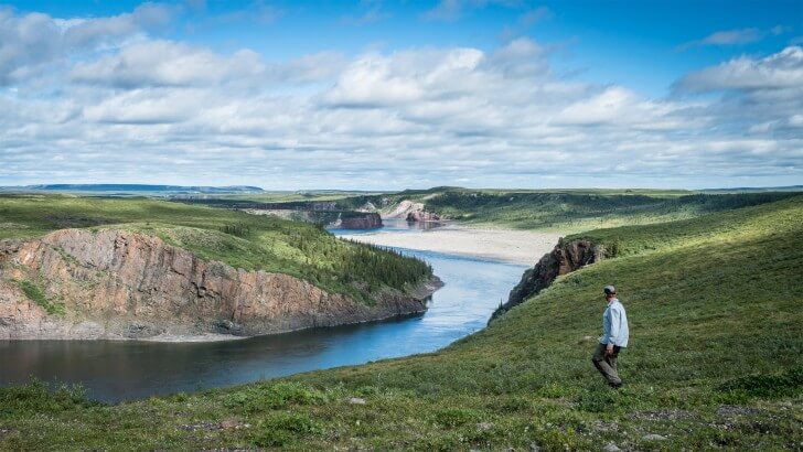
The Coppermine River winds its way through the high Arctic landscape, cutting the easiest path through a remote part of the world until it reaches the Arctic Ocean and the Inuit settlement of Kugluktuk where we ended our journey.

We used human muscle and the power of water to undertake scientific research. Always limited by where the river took us, we began to understand the lives of early explorers restricted by the winds and currents in their efforts to cross seas or explore vast landscapes.
From the top of a mountain, escarpment after escarpment could be seen exposing cliffs of ancient sedimentary rock, once deposited at the bottom of an ocean and now making up the landscape of vast areas of northern Canada, each layer a time capsule of marine conditions over a billion years ago.

We were on the lookout for some of the world’s oldest fossils, microscopic fossils of early eukaryotes (an organism whose cells have a nucleus containing DNA and other organelles enclosed within membranes). Corentin Loron, one of the geologists on the trip, is hunting for fossil species that are new to science; “what’s exciting is finding out how and when life diversified, what the world looked liked a billion years ago, what was living back then.”
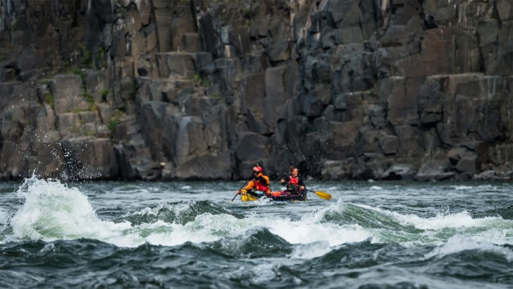
As we descended the river we came across evidence of a huge volcanic eruption known as the Mackenzie volcanic event, over 150 lavas flows piled on top of each other. Similar to the Columbia River flood basalts, evidence from the ancient eruptions here can be found over 2000 km away in southern Canada.
Eruptions of this scale release huge amounts of carbon dioxide and other gases into the atmosphere and have a massive impact on the Earth’s climate and life systems causing huge extinction events like the one that wiped out the dinosaurs. We could certainly see the huge impact it had on the stunning landscape around us, with layers and layers of dark black rock dominating the skyline.

About half way down the 200 km section of the Coppermine River the landscape drastically changed. Green mountains made up of endless layers of dark lava, with a gentle, wide river flowing between them, gave way to steeper-walled canyons of red sandstone overlying the lavas.
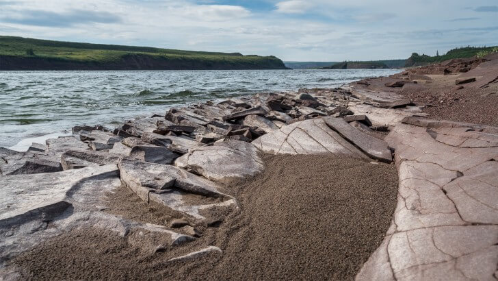
The sandstones are fluvial deposits, laid down by another river, more than a billion years ago. There is something awesome about travelling along a river cutting its way through rocks that are remnants of ancient rivers gone by.

What’s exciting is finding out how and when life diversified, what the world looked liked a billion years ago, what was living back then.”
Structures and minerals in the rocks reveal clues to how they were deposited. You can even tell the direction an ancient river flowed, all from looking at structures formed by the currents and imprinted in the rock. Ripples and mud cracks are preserved to tell the story of the path of an ancient fossilized river.
As the river continued to wind its way through spectacular canyons and gorges and we got closer to our endpoint, we reached some lightly coloured sandstone rocks and darker rocks known as shales that were deposited in a marine environment suggesting that sea level must have risen after the fluvial rocks were deposited.

The shales contained small black flakes, evidence of organic material suggesting that there are microfossils preserved after the volcanic event. Some forms of life must have been able to live through the huge volcanic event, giving us clues to how life was then able to diversify on Earth.
Paddling into the town of Kugluktuk we were left with a story in our minds, not only about paddling down a remote wild river with bears, muskoxen and caribou for company, but also through scenery made up of rocks that told the story of the struggles of early life and environments on our planet.
Dr Vivien Cumming is a writer, photographer and filmmaker specialising in documenting scientific expeditions. You can find more of her work on her website www.viviencumming.com or follow her on instagram and twitter: @drvivcumming
Featured image © Vivien Cumming